Distance: 18.5km (11.5 miles) Total Distance: miles
Weather: Bright
Weather: Bright
I took the bike to Penarth and left it chained to the railings outside the park just up the hill from Penarth Pier. I then drove to the caravan site near Porthkerry Park and parked there.
It turned out to be a bright day. People were up early playing golf at Porthkerry Park. From Cold Knap I was able to walk straight across to Barry Island by jumping over the river that flowed into the sea at Watch House Bay. It was fortunate it was low tide.
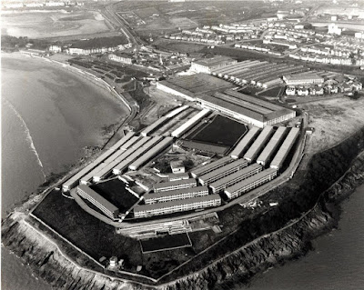
Along the sands at Barry Island or to give it it#s official name, Whitmore Bay, and then around Butlins holiday camp to Jackson's Bay and the start of the docks. I was surprised how much of Barry Docks I was able to walk around.
At the far end of the docks I could not get down to the coast until the hospital at Sully. Once in the hospital grounds I found it difficult to get out again and onto the coastal path, but eventually I found a hole in the fence.
It turned out to be a bright day. People were up early playing golf at Porthkerry Park. From Cold Knap I was able to walk straight across to Barry Island by jumping over the river that flowed into the sea at Watch House Bay. It was fortunate it was low tide.
Along the sands at Barry Island or to give it it#s official name, Whitmore Bay, and then around Butlins holiday camp to Jackson's Bay and the start of the docks. I was surprised how much of Barry Docks I was able to walk around.
 |
| Aerial view of Butlins at Barry in 1989 (Photo: Wales online) |
At the far end of the docks I could not get down to the coast until the hospital at Sully. Once in the hospital grounds I found it difficult to get out again and onto the coastal path, but eventually I found a hole in the fence.
The rest of the day was a pleasant walk along the coastal paths and the beaches and views out to the small Sully Island not far off the coat. In only one place, just past the Captain’s Wife pub, did I have to take to the road to get down to St Mary Wells Bay.
After Lavernock Point I started heading north. The views of England across the Channel were getting closer. The islands of Flat Holme and Steep Holme appeared. As the tide was out so I took to the beach rather than the cliff top paths. It was fairly easy going although pebbly and I made good time.
After Lavernock Point I started heading north. The views of England across the Channel were getting closer. The islands of Flat Holme and Steep Holme appeared. As the tide was out so I took to the beach rather than the cliff top paths. It was fairly easy going although pebbly and I made good time.
Finally it was up onto the busy promenade at the wealthy seaside town of Penarth where everybody was going for their afternoon walk and listening to the brass band. It seemed as popular today as it had been in its heyday of the Victorian era. The short stubby pier was constructed in 1898 and the art deco pavilion added later in 1930. It used to be a favorite place for my parents and grandparents to bring me on a weekend or school holiday. the fact that the pier decking has gaps between the planks making the sea waves visible below was always a bit unnerving for a small child.
The cycle ride back to the car was difficult especially when just past Dow Corning and getting up onto the Barry Top road – very hilly!
When I got back to the caravan park I bought an ice cream in the shop and then drove back to my parents in Cardiff who were just back from their holidays.
The cycle ride back to the car was difficult especially when just past Dow Corning and getting up onto the Barry Top road – very hilly!
When I got back to the caravan park I bought an ice cream in the shop and then drove back to my parents in Cardiff who were just back from their holidays.

No comments:
Post a Comment